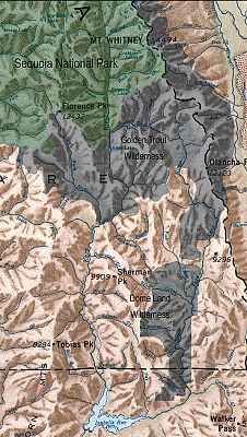
The Kern River runs from the 14,000 ft. slopes of the High Sierra near Mt. Whitney more than 100 miles to the fields and farms of the San Joaquin Valley, near
Bakersfield, California. The Kern is protected by more miles of Wild and Scenic designation than any other river system in the continental U.S. It is the longest whitewater river in the
California.
Located approximately half way through the river’s course is Lake Isabella, a reservoir created by Isabella Dam. Just upstream of Lake Isabella is the town
of Kernville, just downstream the town Lake Isabella.
The reach upstream of Lake Isabella and Kernville is generally referred to as the Upper Kern and the reach below the dam the Lower Kern. The level of
difficulty in these sections ranges from class I to class V+ or VI. The Upper and Lower Kern are easily accessed from a road that follows the River. Class V wilderness runs extend
upstream of the Upper Kern for another 50 miles.
The water on the Upper is from natural snow runoff. The kayaking season ranges from April to mid-July in normal years. The Lower Kern River water is from
Lake Isabella and is dam controlled. Boatable releases usually begin in early June and run through August in normal years. The season may be shorter or longer during drought or high
water years.
In addition to providing water for irrigation the Kern River supports five hydroelectric projects and associated diversions.
For more information about the Kern River, check these links: